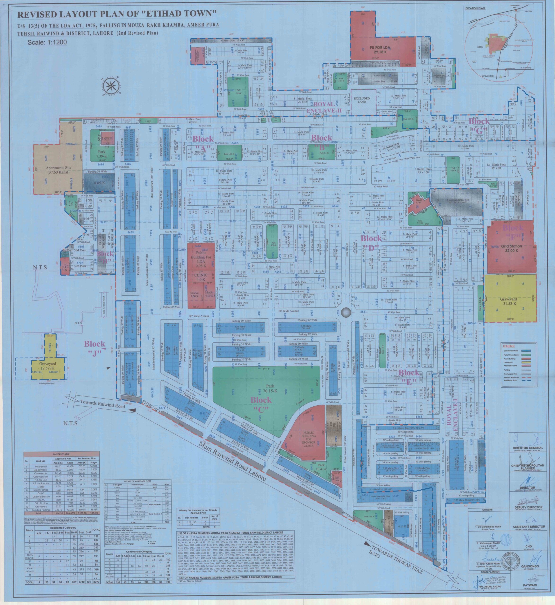
Etihad Town Phase-1 Lahore is a large-scale planned housing scheme developed on Raiwind Road, falling under the jurisdiction of the Lahore Development Authority (LDA). The scheme’s layout has been formally approved as the “Revised Layout Plan of Etihad Town,” sanctioned under Section 13(5) of the LDA Act, 1975, and is registered as the 2nd Revised Plan of the project. The plan is drawn to a scale of 1:1200 and falls in Mouza Rakh Khamba and Mouza Ameer Pura, Tehsil Raiwind, District Lahore.
Location
Etihad Town is accessed directly from Main Raiwind Road, Lahore, with a dedicated entrance point leading into the society, and a second link road connecting towards Thokar Niaz Baig. This dual connectivity places the scheme within easy reach of Raiwind Road’s commercial corridor while also linking it to the wider Lahore ring-road network via Thokar Niaz Baig. The location plan inset on the layout confirms the site’s position along Raiwind Road relative to surrounding landmarks.
Master Plan & Block Distribution
The revised layout divides Etihad Town into multiple residential blocks, an apartment zone, and two Royal Enclave sectors, arranged around a network of boulevards and avenues:
- Block A – developed around a central 7.39-Kanal park, with 10-Marla and 5-Marla residential plots.
- Block B – includes a 4.81-Kanal park and a 5.3-Kanal park, with 10-Marla, 5-Marla, and 18-Marla plot categories.
- Block C – the largest green sector of the society, anchored by a 70.15-Kanal central park along with a 10.41-Kanal park near the Public Building for Sponsor; plots here are largely 5-Marla and 3.33-Marla / 6-Marla commercial strips.
- Block D – a dense residential block with 5-Marla and 3-Marla plots, positioned centrally in the scheme.
- Block E – located toward the southeastern side, adjoining Royal Enclave-I, with 5-Marla and 5.3-Marla plots.
- Block F – situated on the eastern edge next to the 32-Kanal Grid Station.
- Block G – the easternmost block, featuring 12-Marla and 13-Marla plots along with 10-Marla sections.
- Block H – a smaller block on the western side with 5-Marla and 10-Marla plots.
- Block J – located along the western boundary near the entrance, bordered by the Apartments Site.
- Royal Enclave-I and Royal Enclave-II – premium sub-sectors with 5-Marla plots, positioned along the northern and southeastern boundaries of the scheme respectively.
- Apartments Site – a dedicated 37.60-Kanal block on the western side, reserved for apartment development.
Land Use Breakdown
According to the Land Use Table on the layout, the approved plan covered a total area of 1,614.32 Kanal, while the revised plan extends the total scheme area to 2,200.38 Kanal. The revised distribution is as follows:
| Land Use | Revised Area (Kanal) | % Share |
|---|---|---|
| Residential | 768.00 | 34.90% |
| Apartments | 48.39 | 2.20% |
| Commercial | 220.57 | 10.02% |
| Open Spaces | 154.26 | 7.01% |
| Public Building for LDA | 39.17 | 1.78% |
| Public Building for Sponsor | 39.17 | 1.78% |
| Masjid | 3.84 | 0.17% |
| Society Office | 0.25 | 0.01% |
| OHWT (Overhead Water Tank) | 0.62 | 0.03% |
| Disposal Station | 2.00 | 0.09% |
| SWM (Solid Waste Management) | 1.98 | 0.09% |
| Grid Station | 32.00 | 1.45% |
| Graveyard | 44.06 | 2.00% |
| Roads & Parkings | 830.53 | 37.75% |
| Total | 2,200.38 | 100% |
Roads and parking take up the single largest share of the layout, followed by residential plots, reflecting the wide boulevard-and-avenue network built into the scheme.
Residential Plot Categories
The Residential Category table breaks down plot sizes block-by-block, covering 2-Kanal, 1-Kanal, 18-Marla, 12-Marla, 8-Marla, 5-Marla, and 3-Marla categories. In total, the scheme offers 399 plots of 5-Marla, 1,740 plots of 5-Marla (aggregate across blocks), and a combined residential plot count of 2,390 plots across all blocks and both Royal Enclave sectors. Block C carries the highest concentration of plots (528 total), followed by Block B (237) and Block D (313), consistent with these being the primary residential sectors of the scheme.
Commercial plots are similarly categorized by size — 8-Marla, 7.3-Marla, 6.4-Marla, 6-Marla, 5.3-Marla, 4-Marla, and 2-6-Marla — totaling 748 commercial plots, distributed mainly along Blocks A, B, C, D, F, G, H, and the Royal Enclave sectors.
Parks & Open Spaces
Etihad Town is designed with green spaces distributed across nearly every block:
- Park (Block C) – 70.15 Kanal, the scheme’s central and largest park.
- Park (near Public Building for Sponsor) – 10.41 Kanal.
- Park (Block A) – 7.39 Kanal.
- Park (Block B) – 4.81 Kanal and 5.3 Kanal (two separate green belts).
- Park (Block D) – 4.98 Kanal.
- Smaller neighborhood parks are also marked near Block G, the Grid Station sector, and Royal Enclave-I.
Public Buildings & Utilities
The layout allocates dedicated plots for essential civic and community infrastructure:
- Public Building for LDA – 29.18 Kanal (northern sector) plus a further 9.98-Kanal Public Building for LDA near Block D, which also houses a Clinic (4.0 Kanal).
- Public Building for Sponsor – 22.46 Kanal, located near Block C along Etihad Avenue.
- School – 5.50 Kanal, adjoining the LDA public building/clinic complex.
- Masjid – multiple sites of roughly 3-4 Kanal each, distributed across Blocks A, B, and D.
- Grid Station – 32.00 Kanal, positioned on the eastern boundary next to Block F.
- Graveyards – a 31.53-Kanal graveyard on the eastern side (near Royal Enclave-I/Block G) and a separate 12.527-Kanal graveyard on the western side near Block J.
- Excluded Land – a parcel in the northern portion of the scheme that falls outside the approved development area.
Roads & Connectivity
The internal road network is organized in a clear hierarchy:
- Main Boulevard – 150′ wide, running through the core of the scheme.
- 80′ Wide Avenue and Etihad Avenue (80′ wide) – main circulation roads linking Blocks C, D, and E to Royal Enclave-I.
- 60′ and 50′ Wide Roads – secondary arteries connecting Blocks A, B, and D.
- 40′, 35′, and 30′ Wide Roads – standard residential streets throughout all blocks, most paired with dedicated 30′-wide parking strips.
- 20′ Wide Roads – used in the northernmost residential pockets near the PB for LDA sector.
Two main entrances serve the society: one directly off Main Raiwind Road, and another connecting toward Thokar Niaz Baig.
Mortgaged Plots
The layout also lists plots mortgaged against development NOCs, categorized by residential and commercial use across Royal Enclave-I and Royal Enclave-II, with a combined mortgaged residential and commercial area used to secure regulatory approvals from LDA.
Approving Authorities
The layout carries sign-off blocks for the Director General and Chief Metropolitan Planner, Director, and Deputy Director of LDA, along with the Qanoongo and Patwari of the revenue department, confirming its status as a formally sanctioned statutory document. The scheme owners are listed as Ch. Muhammad Munir (private owner), Muhammad Shakil (CEO & Director, Etihad Town Pvt. Ltd.), and Zafar Abbas Kaami (Adaptura Property Holding Pvt. Ltd. / Town Planner).
Frequently Asked Questions
Under which law is Etihad Town’s layout approved?
The layout is sanctioned under Section 13(5) of the LDA Act, 1975, and is registered as the 2nd Revised Plan of the scheme.
Which revenue estates does Etihad Town fall in?
The society is spread across Mouza Rakh Khamba and Mouza Ameer Pura, in Tehsil Raiwind, District Lahore.
What is the total area of the revised Etihad Town layout?
The revised plan covers 2,200.38 Kanal, up from the originally approved 1,614.32 Kanal.
How many residential blocks does Etihad Town have?
The scheme is divided into Blocks A through J (excluding some letters), plus Royal Enclave-I and Royal Enclave-II, along with a dedicated Apartments Site.
What is the largest park in Etihad Town?
The Block C park, spanning 70.15 Kanal, is the largest green space in the scheme.
How is Etihad Town accessed from Lahore?
Via two entrances — one directly from Main Raiwind Road and another linking toward Thokar Niaz Baig.